Currently Empty: AED 0.00


Geo-electrical detector for water and cavity: determines the resistance of the ground at a depth of 100 m and visualizes 2D depth: Water was found by customers up to 100 meters – see our data
Uses detection of water, detection of cavity, and geotechnics.
Modes of operation: Scan of geoelectricity
Objects to be detected: deposits of water, gravel to support water, hoops.
Description
Geoelectrical water detection and cavity: Determines ground resistance to 250m depth and displays 3D depth values: Up to 250 m of water was found by clients
Uses: detection of water, detection of cavity and geotechnics.
Modes of operation: Scan of geoelectricity
Objects to be detected: deposits of water, gravel to support water, hoops.
DESCRIPTION
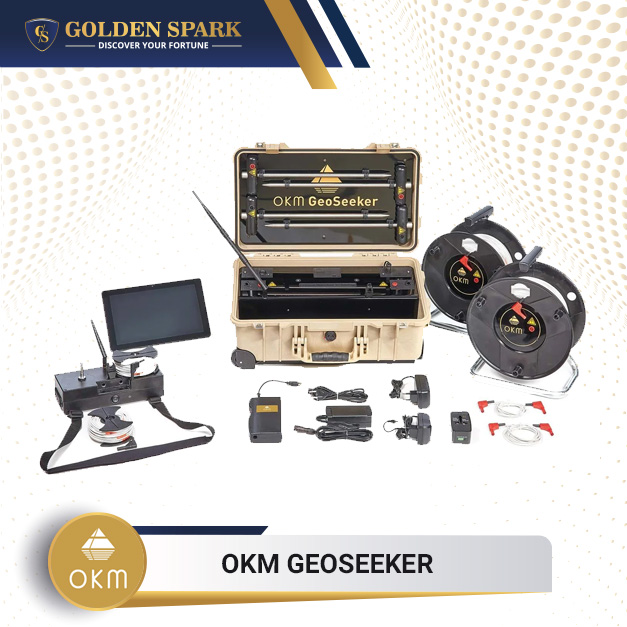
The detector of water and cavity up to a depth of 250 metres.
Are you looking for water resources under the ground or for cavities hidden down to a depth of 250 metres? TheGeoSeekeris a professional geoelectric cavity and detector that measures the resistivity of the soil and visualizes its scanning data in amazing 3D graphics. A geoelectric detector designed and produced in Germany is very mobile and very easy to operate.
The GeoSeeker uses a Schlumberger-based geoelectric measuring procedure to measure the apparent soil resistivity. The detector is able to locate underground water deposits and gravel and the groundwater, as well as hollows such as caves, tunnels, chambers and so on, on the basis of this ground resistivity. The geophysical detector can therefore be used simultaneously as water finder or cavity sensor.
GeoSeeker Scan Modes
A modern Android Tablet PC controls GeoSeeker hardware components entirely. Wireless transmission is made via Wi-Fi for all commands and measurement results. You simply select one of three supported scan modes using the pre-installed software application:
- Active Scan (Accurate)
The GeoSeeker uses two electrodes to inject power into the underground soil during this scan mode. In order to calculate the final resistivity value, two additional electrodes measure the potential difference (fall of tension) in certain scan points. This way you can detect water deposits in underground areas, cave areas or even impermeable layers and barriers. You can define a specific depth range in active scans by carrying out your measurement. You can therefore define a depth of start and end between 5 meters and 250 metres (820 feet).
- Active Scan (Quick)
This scan mode is an accurate scan version quickly. Electric current is also injected into the ground and the potential differences (the voltage fall) are measured, in order to calculate the ground resistivity.
- Passive Scan
In this scan mode, the GeoSeeker uses only two electrodes to read the underground natural voltage (no electrical power is injected into the underground). In this mode only the underground water flows are detected.
GeoSeeker Software
In order to complete the measurement, the software application GeoSeeker provides simple step-by-step instructions. You just follow these images until your measurement is complete. Once the measurements have been completed, the graphic 3d measurement values are represented and displayed on the Tablet PC screen. Some color modification options are provided to optimize your underground water deposits, water-bearing gravel and groundwater level (in blue), and cavities, grottoes, tunnels, chambers, or impermeable layers (shown in reddish colors).
GeoSeeker Transportation
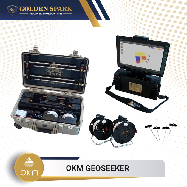
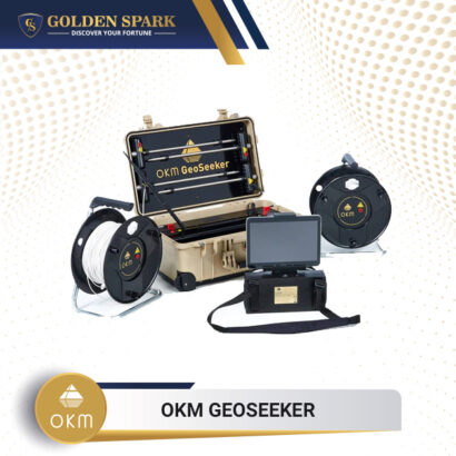
GeoSeeker hardware is integrated into a Peli case that is waterproof and shockproof. Your geo-electric gear is therefore well packaged and ready to carry.
Delivery Scope
1x Controller
1x Android Tablet PC
1x Tablet PC mount
1x Waterproof and shock resistant Pelican case
8x AA battery 1.5 V
1x Power Pack with charger and travel adapter
1x Power Box
1x Charger for controller
1x Charger for Power Box
2x Power cable drum (Ø 290 mm)
2x Voltage cable drum (Ø 120 mm)
4x Electrode
2x Connecting Cable (2 m)
1x User’s manual
Specifications
Voltage Cable Drums (Ø 120 mm)
Dimensions (H x W x D): 360 x 290 x 200 mm
Weight: 6.5 kg
Cable length: 255 m
Markers: 15
Power Cable Drums (Ø 290 mm)
Dimensions (H x W x D): 120 x 120 x 45 mm
Weight: 0.65 kg
Cable length: 26 m
Markers: 25
Controller (Receiving Unit)
Dimensions (H x W x D): 130 x 270 x 110 mm
Weight: 0.6 kg / 2.1 kg (with mounted cable reers and batteries)
Sample rate: 4096 Hz (64 times oversampling of a 512 samples mean value)
Operating time: min. 16 hours (charged batteries)
Charging Time: 3 h / max. 5 h (empty batteries)
CPU: 80 MHz Cortex M3
ADC: 16 bit
Communication with Tablet PC: WLAN-Accesspoint, 2.4 GHz band, channel 6, WPA2
Communication with Power Box: 2.4 GHz band, on-demand, proprietary
Effective Range: –1400 to +1400 mV
Measurement Period per Scan Point: min. 16 seconds
Power Supply (8 AA batteries): 8 – 14 V DC
Input (for Charger): 12 V DC / 1.5 A
Input Resistance (static): approx. 12 MΩ
Power Box (Sending Unit)
Dimensions (H x W x D): 230 x 550 x 360 mm
Weight: 15.8 kg / 18 kg (with mounted Electrodes)
Operating time: 100 h (min. Power) / 40 h (average Power) / 8 h (max. Power)
Charging Time: max. 8 hours
Output: max. 390 V / 0.5 A / 20 W
Communication with Controller: 2.4 GHz band, on-demand, proprietary
Input (for Charger): 24 V DC / 2 A
Internal Power Supply: Lead Acid Battery (2 x 12 V, 10 Ah)
Electrodes
Dimensions (H x W x D): 440 x 120 x 35 mm
Weight: 0.52 kg
The technical data are average values. Minor deviations are possible during operation.
Additional information
| Depth | 250m |
|---|---|
| Language | English |
| System Device | 3D Imaging System |
| Targets | cavity detection, geotechnical engineering, Groundwater, Water detection |